Jordan is ranked the second country worldwide in terms of water scarcity. Subsequently, water share for irrigated agriculture is decreasing with time due to the increased domestic water demand. Managing irrigation water is faced with some constraints including the scattered zones of irrigation and the lack of ground data on cropping patterns and water consumption. Therefore, the need for effective tools and methods for monitoring agricultural water consumption and identifying hotspots in terms of water consumption has been emphasized at all levels to improve water management. Also, monitoring the threats of climate change on the country's water resources is extremely high, particularly in rural areas. The use of ground surveys under these conditions is time consuming and implies high costs. The technological developments of remote sensing data, with improved spatial and/or temporal resolution, provide the opportunity to use these open source datasets for monitoring and assessment of agricultural water use. This can be achieved by mapping agricultural crops and irrigation water consumption (IWC) and hence assessing water withdrawal for crop irrigation. The use of artificial intelligence (AI) algorithms within digital processing techniques has improved these data sources and made them part of the smart water management systems. Different agencies and organizations have integrated remote sensing and archived climatic records to provide open source data for climate change studies and drought monitoring. The challenges, however, remain in validating and calibrating these datasets to form part of water monitoring and management systems.
The University of Jordan's
Water Management and Climate Change Team at the School of Agriculture has been working on developing remote sensing based methods for monitoring agricultural water resources. The work was carried out jointly with international researchers to develop remote sensing based methods for water accounting that identifies possible water amounts that can be developed and classification of water flows in terms of beneficially used and recoverable fractions. The key points of research include:
- Remote sensing based agricultural water accounting for assessing water resources and their use.
- Mapping of agricultural water consumption and identification of cropping patterns and hotspots of groundwater abstraction.
- Analysis of open source data (NASA Power, CHIRPS, FAO WaPOR, WFP-PRISM) for water resources monitoring, drought mapping and climate change assessment.
- Modeling and assessment of climate change impacts on agricultural crops.
|
|
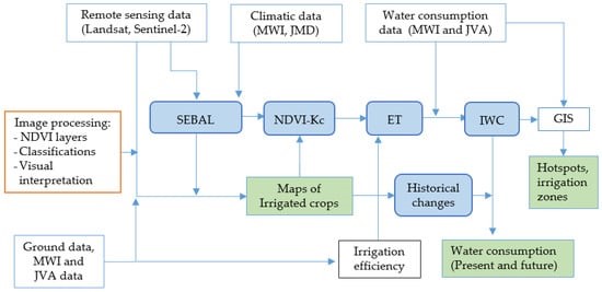
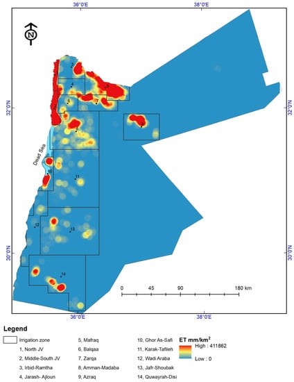
Flowchart of the approach developed for mapping agricultural crops and water consumption (right), with hotspot map for zones with high irrigation water consumption (left).
|
Key results and findings
Results showed that remote sensing and open source data were highly relevant to water management. In terms of water accounting, the portal of FAO WaPOR and ground data enabled the identification the best options for developing water resources (North Jordan Valley as an example. Also, the use of water accounting sheets would enable the identification of best cropping patterns in terms of water use efficiency and recoverable fractions of water.

|
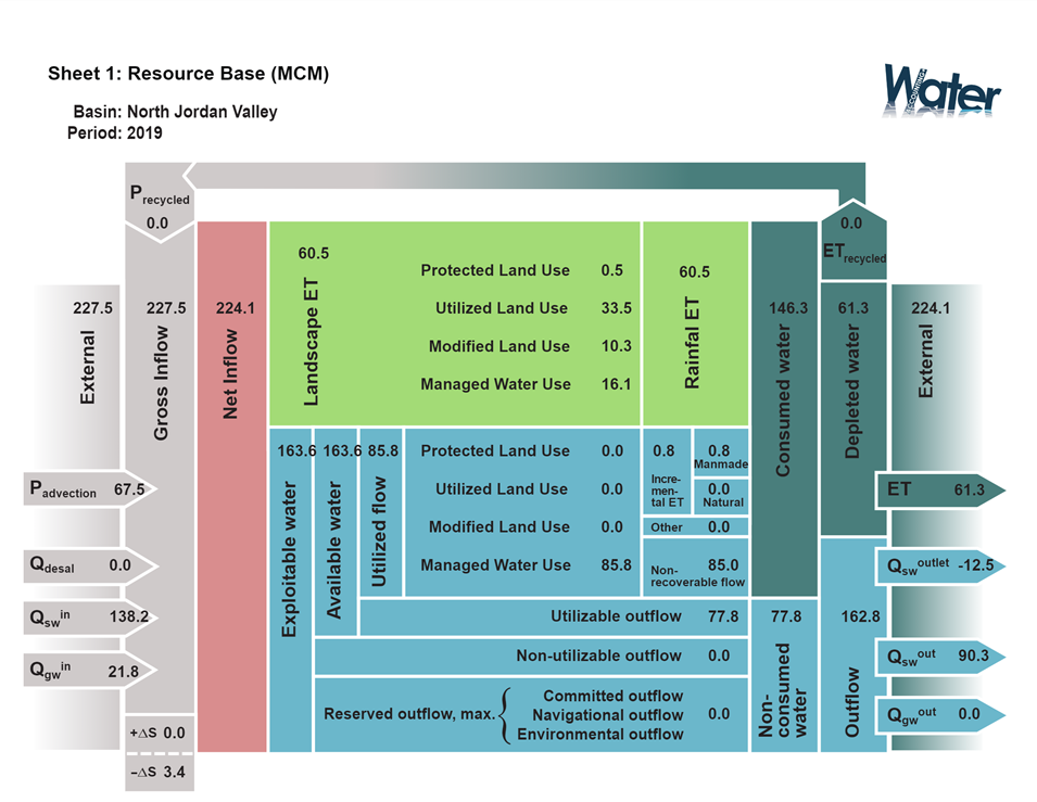
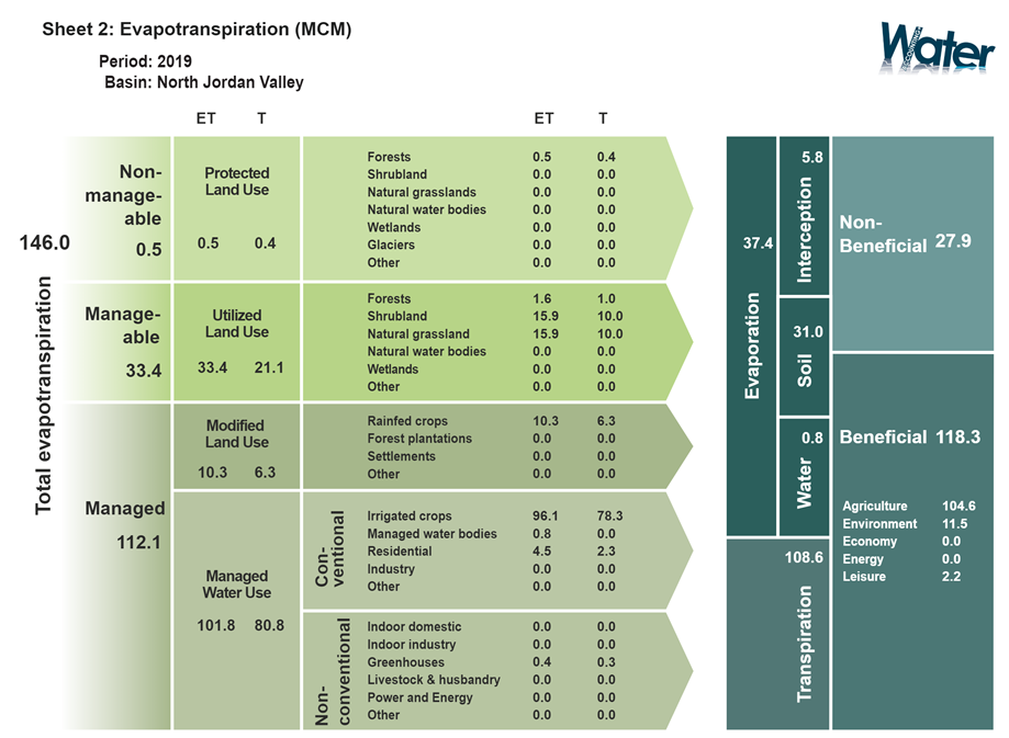
 Examples on the water accounting sheets for resource base (top) and water use (bottom) developed from remote sensing and ground data
 |
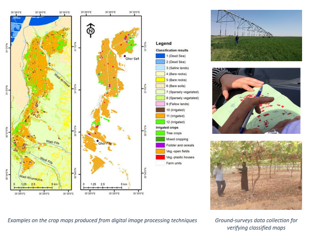
In terms of crop mapping, results showed that remotely sensed maps were accurate and can be updated on regular basis. The use of multi-temporal images with different digital classification algorithms can provide maps of irrigated crops and figures on crop water consumption for each irrigated crop and for each irrigated zone.
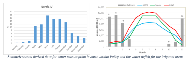
Results showed that it is possible to trace water consumption throughout the season, which would enable the identification of periods with water stress (as shown in the following figure).
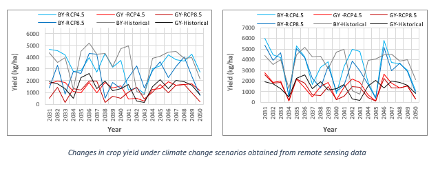
In terms of drought, the sources of data like NASA POWER and CHIRPS would enable the identification of drought affected areas. Also, the use of open source climate change modeled data showed that spatial distribution of adverse impacts could be identified with high accuracy. Fluctuations of yield under future climate were also predicted and mapped under different climatic change scenarios, as shown in the following figure.
References
Al-Bakri J.T., D'Urso G., Calera A., Abdalhaq E., Altarawneh M., Margane A. 2023. Remote Sensing for Agricultural Water Management in Jordan. Remote Sensing, 15(1):235.
https://doi.org/10.3390/rs15010235
Al-Bakri J.T., D'Urso G., Batchelor C., Abukhalaf M., Alobeiaat A., Al-Khreisat A., Vallee D. 2022. Remote Sensing-Based Agricultural Water Accounting for the North Jordan Valley.
Water 14 (8), 1198.
https://doi.org/10.3390/w14081198
Al-Bakri J.T. et al. 2021. Assessment of Climate Changes and Their Impact on Barley Yield in Mediterranean Environment Using NEX-GDDP Downscaled GCMs and DSSAT. Earth Systems and Environment 5(3): 751-766.
https://doi.org/10.1007/s41748-021-00238-1
Al-Kilani M.R., Rahbeh M. and Al-Bakri J.T., Tadesse T. and Knutson C. 2021. Evaluation of remotely sensed precipitation estimates from the NASA POWER project for drought detection over Jordan. Earth Systems and Environment 5(3): 561-573.
https://doi.org/10.1007/s41748-021-00245-2